
Before criticizing the management of the water level, let’s not forget it’s thanks to this reservoir of Hydro-Québec that we can enjoy this amazing body of water. Without this reservoir we would all be in a field or just near a stream. We must accept that the reservoir’s level fluctuates regularly depending on a number of factors.
For questions or additional information contact us: HERE
Water Levels:
- To see the current water level on Lac Poisson Blanc: click here
- Forecast of water levels for the next two days: click here
- To find specifics of water levels of Québec waterways: click here
Here is a study concerning water level policies for dams: Huaringa_Alvarez_Uriel_Francisco_MScA_2014
What are the legal & environmental concerns about water levels on a reservoir like our lake: click here
Our lake is a reservoir and is part of the Ottawa River watershed, which is governed by Ontario Hydro and Hydro-Québec.
Here is a link to get current information about our regional watershed.
Click: http://ottawariver.ca/forecast.php
EVOLUGEN Power and the other dam managers operating on the Lièvre River watershed have a primary objective of preventing flooding on the Lièvre River as well as on the Thousand Islands River. In flood and drought periods, the goal is to manage water in a way that minimizes damage to all stakeholders, including riparian owners.
In the watershed of the Lièvre River, 16 municipalities, their citizens and the relevant departments and agencies are now better prepared to act in the event of a disaster. Supported by Dam Managers and Regional Emergency Organization, municipalities and departments completed an emergency response planning process and shared the results of their work with the public in the fall of 2010. Although this joint plan may be useful for any type of disaster, the scenario used for the approach was that of an exceptional flood or dam failure. For more details, consult your local municipality.
If you have any comments or questions, please email: infolalievre@brookfieldrenewable.com
or call: 819-986-4628 / toll free: 1-877-986-4364.
Normal water level 201.03 metres (from June to August)
Maximum water level: 201.09 metres (usually in April and May)
Flooding: over 202 meters
Why our Water Levels keep Fluctuating:
What is a Watershed?
(Also known as a drainage basin, catch basin, or hydrographic basin)
A watershed is defined as an area of land where all the surface water drains into the same place, whether it’s a creek, a stream, a river or an ocean. Therefore, all precipitation, such as rain or snow, that falls on a watershed ends up flowing to the same place.
Source: http://www.canadiangeographic.com/watersheds/map/…
http://www.environnement.gouv.qc.ca/…/dulie…/FS_DuLievre.pdf

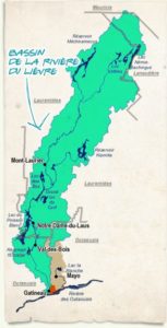
We’re part of the La Lièvre watershed
We are trying our best to keep you informed through our Facebook page!
Many people don’t understand why the water level keeps fluctuating; here is a video explaining why…
https://www.facebook.com/hydroquebec1944/videos/2252068134856789/
About the Poisson Blanc Reservoir:
Our reservoir affects many municipalities along the Lièvre River to Buckingham, then combines with other reservoirs of the Ottawa river watershed. There are three authorities governing the dams so there must be coordination between all of them.
Unfortunately for us, what is considered the priority is the safety and security of those living in the urban areas of Gatineau, Ottawa and Montréal. There is a understanding that the water level should be kept stable until Labour Day, and after that it may go down rapidly for many reasons, including the maintenance of the different dams.
History of Legal Procedures to Regulate the Water Level & Other Communications:
Another association (which no longer exists) tried to regulate the level of our reservoir by legal means. The reason of the legal procedures was for the shoreline erosion but not really to prolong the period when the water level is stable till the end of September. So, presently for us, if we want to guarantee a certain level we must reach all owners affected including those living up north of the Poisson Blanc. For this to happen we must prepare our case which is a long process.
Sources are from the archives of the «Association les amis de la lièvre» (this association is no longer active) and also COBALI.
The official act of 1992 defining our water level:
To download: Download
Legal procedure to stop the erosion of the reservoir presented by :
ASSOCIATION DES RÉSIDENTS RIVERAINS DE LA LIÈVRE INC
To download: Download
In 2006 a plan was approved for the management of the water level:
To download: Download
Last official document from the Association «Les amis de la Lièvre» which include information about the legal procedures and also history of our reservoir:
To download: Download
General snapshot of our watershed in 2013:
To download: Download
Official communication in 2015 by our Association had concerning the water level.
The letter was send by Ronald Thomas (Representative for Newton Bay)
To download: Download
THE LATEST COMMUNICATION ON THIS MATTER:
Since 2020, the Association has been receiving weekly forecasts for the months of September and October. This is the result of many months of discussion between the dam managers and our committee. (Members: Jeff Parkes, Larry Villeneuve, Margaret Robinson and JoAnne Roy Foster).
To download: Download